HURRICANE UPDATE:
Hurricane Joaquin
Category 4
Max Sustained Winds: 130mph
Pressure 936mb
I was very reluctant to do a post so far out of a storm. Too many times in the past I have been more upfront about posting about a storm and it being a non-factor. As the storm enters the 3-4 day forecast window. It becomes more and more evident that this storm in some respects is going to have a major impact in some way or another on millions of Americans. Here are the 5 things that YOU need to know moving forward about this storm and the way that hurricane forecast's are produced.
1. Do not trust one model as law. They are just a mathematical estimate of physical properties in the atmosphere at its current state. The atmosphere is a dynamic state and thus changes constantly. Therefore the forecast will change constantly accordingly. Models can be used as guidance to help determine trends within a system. In this case for this storm in particular there are two different factors that will determine whether this storm will be catastrophic for the Mid-Atlantic and Northeast United States, or be an afterthought with lingering showers and breeziness and high surf for coastal regions.
 |
| GFS model outlook as of 7am this morning |
2. Factor #1: Steering mechanisms. Storms have to follow a wind pattern. In the cases of most intercontinental storm or frontal systems. These will follow upper level wind patterns which can be caused by a number of factors. For the tropics, both land based and ocean based steering mechanisms are a factor making path predictions extremely complex. In this particular situation a high pressure system in the Atlantic was originally supposed to lock the storm into its route up the East Coast, even having it move back inland as seen in a situation such as Sandy. In the updated models, this high pressure is not well developed and thus the GFS and Euro models have the system going well out to sea. This high pressure would be shifting eastward from Canada to move over the Atlantic. In the Canadian model, this high pressure is so well developed that landfall looks to be more direct.
 |
| 850 vorticity map via NWS/NCEP |
3. Factor #2- Strength of the storm due to shear (or lack there of). Shear or vertical shear is the differing wind patterns with increasing height. The more shear there is, the less powerful a hurricane can become as the shear breaks down the storm, especially in the eye. If the eye is more well developed. Then the storm can continue to intensify over warm waters with high winds, lower pressure, more moisture. It is basically a positive feedback. The opposite is of course true if shear is introduced to the storm. Which may happen as the storm approaches where it was scheduled to make landfall.
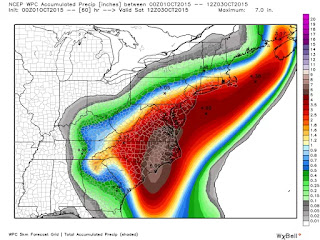
4. Even if it is out at sea, there will still be impacts for our region most likely. By this weekend, we will most likely have received 4-10 inches of rain this past week. Flash flooding is definitely not out of the question, especially for regions close to streams and rivers. Remembering to avoid backroads that have a tendency to overflow with rain water and to not pass through areas where you cannot see the road can help alleviate any concerns about the floods themselves. Right now though, the Bahamas are completely a mess and may require extensive efforts for recovery from this storm.
 |
| Rainfall forecast estimation via NCEP (via CWG) |
5. This storm serves as a reminder that hurricanes that impact the East Coast remain a concern. They may not be an every year occurrence, but with ocean waters continuing to rise and climatologally norms becoming a mystery, it is hard to tell whether these hurricanes will be an anomaly or not. Doing our best to have the tools necessary to prepare for a hurricane, especially in areas like Lower Manhattan which proved exposed to the elements 3 years ago, can be very beneficial moving forward. It also proves the power of social media can bring immediacy in terms of informational flow and updates. Keep the sources reliable though. I tend to only trust NHC (National Hurricane Center), WeatherBell for model information, and locally the CWG (Capital Weather Gang) along with TerpWeather give very accurate and objective information about storms.
That is all for now.
For now, stay tuned. This storm is far from over.
-Jimmy
P.S I was using this site to see historically how often we see tracks such as the one we are seeing with this storm. Very cool site. Would suggest for climate nerds like myself.
Link: http://coast.noaa.gov/hurricanes/
