This weekend a strong Winter Storm will affect millions of
people in a system known to many as a nor’easter. This storm is called such
because of its northeasterly track and a strong low-pressure system that forms
off of the Atlantic Coast and feeds moisture and cold air in. This storm seems
like it will mostly affect the Northeast and Northern Mid-Atlantic areas along
with regions farther west and north of the DC metro area. This does not mean
that impacts will not be present, as this storm could bring a variety of
precipitation types: rain, freezing rain, sleet and snow.
I will be providing a timeline for this storm as it
approaches and begins to form this evening into tonight and eventually moving
out of the region by mid-morning tomorrow. Also, I will try to give an accurate
forecast for snowfall/sleet/ice totals, though this could remain a challenge
due to the fact that road conditions, surface temperature and precipitation
type could play a major factor in the true impact of this storm
Friday Afternoon: The storm will arrive a little after 4pm
and will begin as rain. Temperatures will be steady in the high 30s, but
dropping quickly as sundown approaches. Winds out of the south at 5-10mph. Do
not be surprised if you see flakes even in the early evening due to dew points
being below freezing
Friday Evening: By the evening, the surface temperature will
have dropped enough for sleet and mixed precipitation to start. Do not be
surprised if snow begins at this time, but it looks more and more likely due to
an inversion in the upper atmosphere that snow accumulation at this time will
be minimal at best. Temperatures will be slightly above freezing at this point,
with winds shifting to out of the SE.
Friday Night (10pm-1am)-This is the trickiest point of the storm
with the most uncertainty with it; mostly due to the fact that the temperature
around the region is supposed to be 32, or freezing. This means that a variety
of precipitation forms could be present at different areas throughout the DC
metro. This is also the time where freezing rain will begin to be a factor.
Freezing rain is when rain falls from the sky and freezes on contact to the
surface. This produces the highest impact for travel and surfaces. This is also
going to be the heaviest of precipitation for the storm.
Saturday early (1am-5am)-At this point of the storm,
precipitation could shift back to rain, freezing rain will continue or there
could be a shift towards some flakes. All of this has to do with what is going
on just above the surface. It is looking more and more that warm air will cause
a cold rain rather than snowfall and that amounts of accumulation will be
minimal at best. Temperatures around this point will remain steady at 32 or
even rise just above before sunrise.
Saturday morning (5am-9am)-By this point, as a few stray snow showers may linger, but no additional accumulation will be likely. Temperatures
will be rising quickly after sunrise, which means the chance of mixed
precipitation drops significantly after 7am. Winds will pick up out of the
Northwest gusting 15-20mph. The storm may linger until mid-morning, though the
majority of the precipitation will have moved to the north and east.
Saturday mid-day-Cloudy skies, cold and raw outside with
gusty winds, though it should clear by mid to late afternoon. Highs near 40.
Winds gusting 20-25mph out of the Northwest.
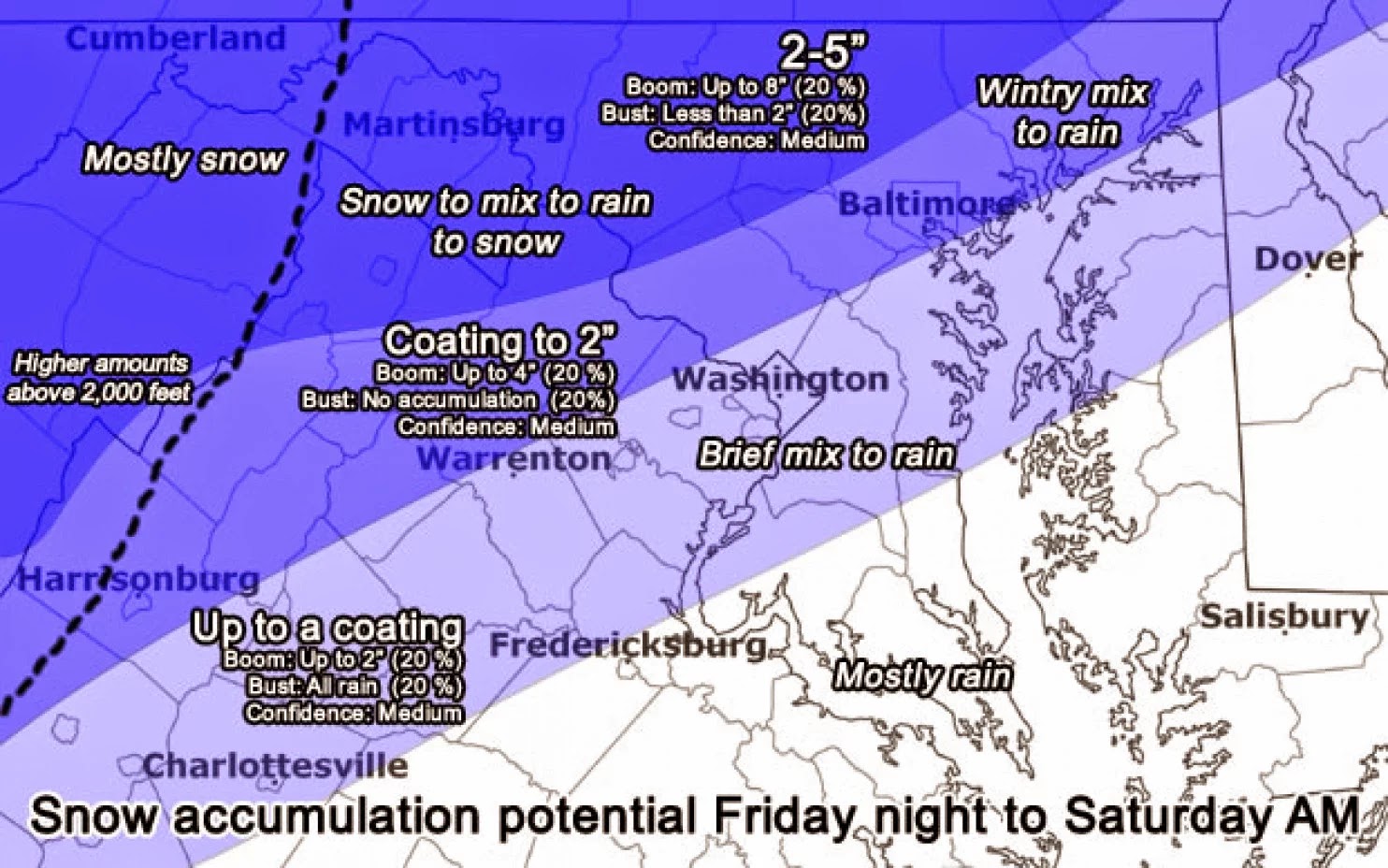
Total accumulation for the DC Metro area: Coating to a half
inch of mixed precipitation with a chance of >.05 inches of freezing rain.
 |
| Source: Capital Weather Gang @captialweather |
Impact: Low (though may be higher), if the roads are well
treated this storm should be no problem. Though I would not suggest being out
around the time where the heaviest of precipitation will be passing 10-1am.
Stay safe out there GMU!!
-James Luehrs

