Friday, January 30, 2015

What is an Alberta Clipper?

This past week’s winter storm came in two parts.  First, an Alberta Clipper struck the mid Atlantic region with a coastal low-pressure system following right behind it. You may have heard the term Alberta Clipper multiple times this past winter season, but what exactly is an Alberta Clipper?

Courtesy of WDBJ.com
An Alberta Clipper hails its name from the northwest Canadian province of Alberta due to its formation over the region. Although it often originates from Alberta, it can sometimes also form around the nearby Canadian provinces of Saskatchewan and Manitoba and even as far south as Montana. The Clipper part of the name comes from the fast moving clipper sailing ships of the late 19th century. Therefore, the Alberta Clipper is a rapidly moving low-pressure system that often brings winter storms to the U.S.  The system forms on the east side of the Canadian Rockies mountain range after warm, moist air from the Pacific Ocean moves over the mountains. Although, Alberta Clippers can bring snow to the regions it travels over, it’s a different scenario directly on the east side (leeward) of the Rockies. Alberta repeatedly experiences Chinook winds. Chinook, “snow-eater”, winds are warmed from the Pacific Ocean and can melt up to one foot of snow. After the Alberta Clippers’ formation, it gets caught in the jet stream and moves from the west-northwest direction to the east-southeast. In the winter months the jet stream dips further south down into the U.S. Thus, this is a primary reason why we often see more of these storms because they make their way through the Great Plains into the Mid-West and finally arrive in the mid-Atlantic region. After it moves through the mid-Atlantic region it exits land and moves over the Atlantic Ocean, but sometimes it can hook up to the north and intensifies again over New York, New Jersey, Pennsylvania and New England; it can drop significant amounts of snow over the New England states.  Other times, its route can take it over the Great Lakes region and can produce enhanced lake-effect snow for the Ohio River Valley region.


Courtesy of AccuWeather.com
Just like last week’s storm, these systems usually bring anywhere between one to three inches of snow due to their fast moving pace. The quicker speed of a clipper inhibits moisture development and the system cannot hold as much vapor. Accompanying these storms are gusty winds and frigid temperatures. Wind chill temperatures can dramatically drop into the mid -30 degrees Fahrenheit. A daunting task to meteorologists is forecasting snowfall totals with these systems because of snow bursts. Stronger bursts of snow frequently intensify over regions and can dramatically increase snowfall totals over a localized area.

Sunday, January 25, 2015

Winter Storm Juno

WINTER STORM ALERT!

The DC area could be on the southern end of potentially one of the more memorable storms in the past couple of years. Due to its pure uncharacteristic nature in formation and outlandish snowfall predictions, there has been a media frenzy in the past 24 hours leading up to the eve of the storm's development. Without getting into why the storm is so much different than winter storms in the past, what is prudent to understand is that this storm will cause blizzard conditions for millions and moderate to heavy snow for the entire Mid-Atlantic and Northeast regions.

Now to where we stand in all of this mess. First realize that this storm is a two part equation. The first part is the clipper system which is a fast moving swath of cold air with snow bands out in front of it. The snow will coincide with the rapid cooling tonight, and will ramp up tomorrow morning. At its height snowfall rates of half an inch to an inch per hour would not be out of the question. Again this system is very quick moving, and like the last system that came through the area on Friday into Saturday, it will start as a rain/snow mix. As the temperature drops though snow will begin to stick more rapidly. Road conditions and visibility may be a factor with this storm. The initial storm will move in this evening from the Northwest with snow beginning in Western Maryland and moving across the mountains and into this area.

Currently it looks like the switch over to snow will be well after midnight, but it could very well be before depending on how quickly surface temperature drops.

Now the tough part about this storm is part two. Part two looks like it will miss us completely and only affect areas to our North and East, such as Annapolis, Baltimore and Ocean City. This is where the strong coastal low materializes off of Cape Hatteras and a jet of moisture will bring copious amounts of snow to areas near the shoreline. This includes Delaware, New Jersey, New York, Connecticut, Massachusetts  etc. These areas will also be experiencing very high winds as high as 60 mph, which is considered blizzard conditions. Snow totals for these regions will be in the feet not inches. This low is set to form late Monday night into Tuesday. Whether or not this will affect our area is still in question. Most of the models point to a minimal impact for the immediate DC metro area, but do not be surprised if another inch or two is on the ground before it is all finished.

Here is the timeline for the storm and with corresponding maps showing you the progression of the storm (Via NOAA)


Sunday Evening: Temperatures will remain in the 40s until around 6pm. At this point they will start dropping right around the time rain starts to move in. Rain will begin as light drizzle. Winds will shift out of the East at 5-10mph.


Sunday Night: Rain will continue, though flakes may mix in at times. By 10pm the temperature will be in the mid to low 30s and accumulation may start occurring especially on soft surfaces.


Monday Early: By about 2:00 am EST, it will be all snow for most of the region with the exception of possibly the city and eastern and southern suburbs which may stay all rain until this time. Temperatures will be in the low 30s, snow will be relatively light. At this time maybe a half of inch of snow on the ground. 


Monday Morning: By 6:00 EST, snow will be falling more steadily and winds out of the ESE will accompany the heaviest of the accumulations. Temperatures will remain in the 30s with wind chills in the low to mid 20s.


Monday Mid-Day: Temperatures will have warmed slightly, though no switch over to rain. Snow will still fall intermittently throughout the day in the form of snow showers. Look by this time for total accumulations to be around 1 inch.


Monday Afternoon/Evening: Snow showers will dissipate but flurries may still remain until sundown. Winds will start gusting at 20-25mph more heavily out of the North and temperature will drop once again to the upper 20s with wind chills in the mid teens.

Monday Night: The second half of the storm will produce bands of snow showers that may be moderate at times. Temperatures will stay in the upper 20s and winds will stay gusting out of the North. Another 1 inch of snow expected.


Tuesday Morning: This storm will have departed by this point. Leaving behind brisk temperatures, gusty winds and hopefully a decent amount of powder. Nothing too much to worry about for this area.


Impact: Low/Medium – I would expect the roads to be very slick and dangerous especially has the storm intensifies Monday night. And even tomorrow morning commutes may be affected due to reduced visibility

Total snowfall prediction for Fairfax: 2-3 inches

Confidence: Medium/Medium High

48 hour Snow Forecast for this storm (Via GFS Model)


- Jeremy Goldstein&James Luehrs

Friday, January 23, 2015

Winter Storm Nor'easter

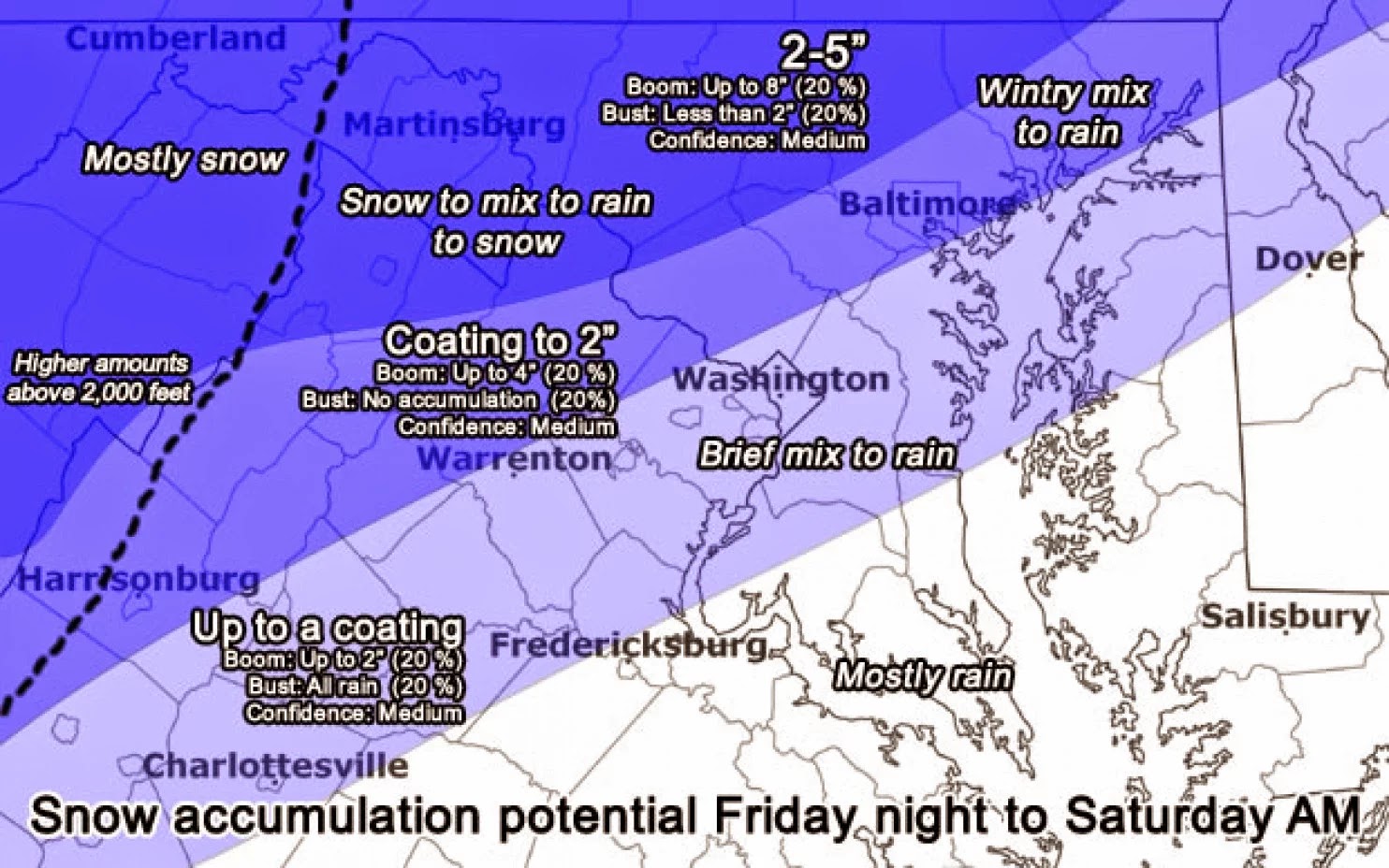
This weekend a strong Winter Storm will affect millions of people in a system known to many as a nor’easter. This storm is called such because of its northeasterly track and a strong low-pressure system that forms off of the Atlantic Coast and feeds moisture and cold air in. This storm seems like it will mostly affect the Northeast and Northern Mid-Atlantic areas along with regions farther west and north of the DC metro area. This does not mean that impacts will not be present, as this storm could bring a variety of precipitation types: rain, freezing rain, sleet and snow.

Most models are presenting a warmer outlook to the storm than initially forecasted which will favor more rain closer to the DC and along the I-95 corridor with a chance of freezing rain and sleet and more snow to the west especially along the I-81 corridor. 

I will be providing a timeline for this storm as it approaches and begins to form this evening into tonight and eventually moving out of the region by mid-morning tomorrow. Also, I will try to give an accurate forecast for snowfall/sleet/ice totals, though this could remain a challenge due to the fact that road conditions, surface temperature and precipitation type could play a major factor in the true impact of this storm

Friday Afternoon: The storm will arrive a little after 4pm and will begin as rain. Temperatures will be steady in the high 30s, but dropping quickly as sundown approaches. Winds out of the south at 5-10mph. Do not be surprised if you see flakes even in the early evening due to dew points being below freezing

Friday Evening: By the evening, the surface temperature will have dropped enough for sleet and mixed precipitation to start. Do not be surprised if snow begins at this time, but it looks more and more likely due to an inversion in the upper atmosphere that snow accumulation at this time will be minimal at best. Temperatures will be slightly above freezing at this point, with winds shifting to out of the SE.

Friday Night (10pm-1am)-This is the trickiest point of the storm with the most uncertainty with it; mostly due to the fact that the temperature around the region is supposed to be 32, or freezing. This means that a variety of precipitation forms could be present at different areas throughout the DC metro. This is also the time where freezing rain will begin to be a factor. Freezing rain is when rain falls from the sky and freezes on contact to the surface. This produces the highest impact for travel and surfaces. This is also going to be the heaviest of precipitation for the storm.

Saturday early (1am-5am)-At this point of the storm, precipitation could shift back to rain, freezing rain will continue or there could be a shift towards some flakes. All of this has to do with what is going on just above the surface. It is looking more and more that warm air will cause a cold rain rather than snowfall and that amounts of accumulation will be minimal at best. Temperatures around this point will remain steady at 32 or even rise just above before sunrise.  

Saturday morning (5am-9am)-By this point, as a few stray snow showers may linger, but no additional accumulation will be likely. Temperatures will be rising quickly after sunrise, which means the chance of mixed precipitation drops significantly after 7am. Winds will pick up out of the Northwest gusting 15-20mph. The storm may linger until mid-morning, though the majority of the precipitation will have moved to the north and east.

Saturday mid-day-Cloudy skies, cold and raw outside with gusty winds, though it should clear by mid to late afternoon. Highs near 40. Winds gusting 20-25mph out of the Northwest.

Total accumulation for the DC Metro area: Coating to a half inch of mixed precipitation with a chance of >.05 inches of freezing rain.


Source: Capital Weather Gang @captialweather
Impact: Low (though may be higher), if the roads are well treated this storm should be no problem. Though I would not suggest being out around the time where the heaviest of precipitation will be passing 10-1am.

Stay safe out there GMU!!

-James Luehrs

Tuesday, January 6, 2015

Winter Storm Surprises the DMV - January 6, 2015


The D.C. Metropolitan area experienced it’s first glimpse of winter this morning as snow blanketed the region. This clipper was predicted to produce snow totals around 1-2 inches with more snow in the northern and western suburbs, but this clipper over performed and brought with it up to 5 inches in some areas. The storm began around 5 A.M. this morning. The snow continued to fall until about noon before it began to taper off. The official snowfall total at Reagan National Airport was 2.4 inches.

This storm was caused by a weak area of low pressure called an Alberta clipper.  “Alberta clippers” are storms that have a tendency to dive south from central Canada and then cross southeast through the northern Plains. The clipper then travels through the Ohio Valley and into the Atlantic Ocean.  Clippers differ from coastal lows (nor’ easters) because they are relatively weak regions of low pressure. Since they are quick and lack oceanic moisture, they generally do not produce a lot of snow. Clippers usually produce only a dusting to an inch of snow.

With this storm brought a messy morning commute.  The Virginia Department of Transportation (VDOT) prepared with over 500 plows on the road. VDOT also began pretreating the roads last night. Although VDOT was prepared, many side streets were not plowed and were hard to navigate through this morning.

With only a couple inches in the forecast, many school systems decided to open on time today, most notably Fairfax County Public Schools (FCPS). Many people took to social media to express their frustration. At one point, “#closefcps” was trending worldwide. FCPS later released a statement apologizing for opening schools this morning.  The roads did begin to clear up the afternoon as temperatures rose slightly, making the afternoon commute a little less hectic.

For those who did get to stay home and enjoy the snow, it was quite a pretty scene outside. The storm produced a fluffy snow, which results from very cold associated air mass and low moisture content air. This type of snow is not the best for building snowmen and making snowballs, but it is easy to shovel.

The snow should stick around for a few days because temperatures are about to plummet. The high for Wednesday is around 28 degrees with wind chills in the single digits.  This cold pattern is going to continue for the rest of the week.  The good news (or bad news, depending on if you like snow) is that the rest of the week should remain sunny.  However, I advise everyone to remain cautious if you plan on heading out tonight or tomorrow morning, as many side roads have still not been treated. With temperatures dropping quickly, these roads will quickly become slick again.