One decade after Hurricane Katrina's record-breaking season,
what should we expect of the 2015 hurricane season?
The official start to the Atlantic Hurricane Season started
earlier this month on June 1st. However, the Atlantic Basin's season was off
to an early start with Tropical Storm Ana making landfall along the South
Carolina coast on May 10th –three weeks before the start of the 2015
hurricane season. Also, the Pacific Basin has already seen the development of
two category 4 hurricanes, Andres and Blanca. So at this juncture we need to
ask if these strong storms are early indicators of a busy hurricane season?
 |
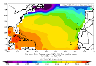
| Sea Surface Temperatures (SSTs) over the Atlantic Ocean measured in Kelvins. http://www.esrl.noaa.gov |
One important variable to analyze while forecasting tropical
weather is the impact of an El Nino or La Nina event. You may ask why a natural
phenomenon occurring over 3,000 miles away from the United States is important
in forecasting? It's important because the effects of the El Nino and La Nina
events are felt globally. In respect to the United State's tropical weather, El
Nino brings cooler waters and stronger wind shear (subsidence) to the Atlantic
Ocean—which suppresses hurricane development. El Nino’s role in this year’s
hurricane season still remains undefined; however, we are already seeing El
Nino’s effects on our wind and pressure patterns locally and within the
mid-Atlantic region. The National Oceanic and Atmospheric Administration’s
(NOAA) Climate Prediction Center estimates there is an 80 percent chance of El
Nino persisting throughout the rest of the year and the event will be stronger
than last year. El Nino is forecasted to strengthen during the peak months of
the Atlantic Hurricane season.
Another essential variable to hurricane development is warm
sea surface temperatures (SSTs). As of March 2015, warm SSTs were found in the
western Atlantic and throughout the Caribbean Sea. Meanwhile, in the eastern
Atlantic, SSTs were below average. The cooler than average water and SSTs tend
to suppress hurricane development and intensification. It’s significant to
bring attention to the location of the warmer SSTs because many damaging
hurricanes do form in the western Atlantic Ocean.
 |
| NOAA's 2015 Atlantic Hurricane Season Outlook NOAA.gov |
Overall, NOAA is predicting a below average hurricane season
with a 70 percent likelihood of 6-11 named storms, 3-6 hurricanes, and 0-2
major hurricanes (category 3 and higher). According to Colorado State University,
there is approximately 28 percent chance of at least one major hurricane making
landfall along the entire U.S. coastline, 15 percent chance of a major
hurricane making landfall on the east coast including Florida, and a 15 percent
chance that the area from the Gulf Coast to Brownsville, Texas will see the
landfall of a major hurricane. These predictions come from statistical
predictors and dynamic models combining SSTs, sea level pressure, and upper and
lower atmospheric conditions, such as wind shear and wind patterns. A low
number of tropical storms does not necessarily mean that the storms which do
develop won’t be strong or have destructive capacity. NOAA Administrator
Kathryn Sullivan, Ph.D. warns, “A below-normal season doesn’t mean we’re off
the hook. As we’ve seen before, below-normal seasons can still produce
catastrophic impacts to communities.”
For safety and preparation tips during hurricane season, please review my article from last year's season, Summer Travel and Weather Advisories. No matter where your travels take you this summer, be aware of the always changing weather!
-Katie Thomas
For safety and preparation tips during hurricane season, please review my article from last year's season, Summer Travel and Weather Advisories. No matter where your travels take you this summer, be aware of the always changing weather!
-Katie Thomas
No comments:
Post a Comment